About U.S. Route 1
U.S. Route 1 in Massachusetts
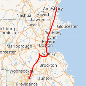
U.S. Route 1 (US 1) is a major north–south U.S. Route in the U.S. state of Massachusetts, traveling through Essex, Middlesex, Suffolk, Norfolk, and Bristol counties. The portion of US 1 south of Boston is also known as the Boston–Providence Turnpike, Washington Street, or the Norfolk and Bristol Turnpike, and portions north of Boston are known as the Northeast Expressway and the Newburyport Turnpike.
Route 1 description
From the south, US 1 enters Massachusetts from Rhode Island, immediately entering the city of Attleboro. It closely parallels Interstate 95 (I-95) as it goes through the towns of North Attleborough, Plainville, Wrentham, Foxborough (where Gillette Stadium is), Walpole, Sharon, Norwood, and Westwood. US 1 then has a wrong-way concurrency with I-95 up to the interchange that is the southern terminus of I-93. US 1 then travels concurrently with I-93 from Canton through Downtown Boston; Route 3 joins the concurrency in Braintree. In Downtown Boston, Route 1A and Route 3 separate from US 1 to head toward Logan International Airport and Cambridge respectively, and I-93 and US 1 separate just after passing through the O’Neill Tunnel and crossing the Leonard P. Zakim Bunker Hill Memorial Bridge. US 1 continues north, crossing the Tobin Bridge as the Northeast Expressway and traveling through Chelsea, Revere, and Malden, then as a four- to six-lane expressway through Saugus, Lynnfield, and Peabody. The route through Saugus was once known for its abundance of kitschy roadside commercial architecture, including the 68-foot (21 m) neon cactus of the Hilltop Steak House and tiki-styled Kowloon Restaurant.[2][3] From Peabody, US 1 again closely parallels I-95 going through the towns of Danvers, Topsfield, Ipswich, Rowley, Newbury, and Newburyport. In Newburyport, US 1 has a mile-long (1.6 km) freeway segment that bypasses downtown and the waterfront areas; Route 1A joins the freeway shortly before it crosses the Merrimack River, entering Salisbury and becoming a surface arterial again. Three miles (4.8 km) later, it enters the state of New Hampshire.
Route 1A runs alongside US 1 in four parts of the state.
U.S. Route 1

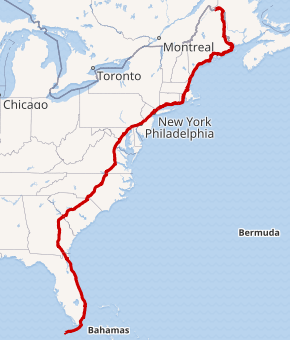
U.S. Route 1 or U.S. Highway 1 (US 1) is a major north–south United States Numbered Highway that serves the East Coast of the United States. It runs 2,370 miles (3,810 km) from Key West, Florida, north to Fort Kent, Maine, at the Canadian border, making it the longest north–south road in the United States.[2] US 1 is generally paralleled by Interstate 95 (I-95), though US 1 is significantly farther west (inland) between Jacksonville, Florida, and Petersburg, Virginia, while I-95 is closer to the coastline. In contrast, US 1 in Maine is much closer to the coast than I-95, which runs farther inland than US 1. The route connects most of the major cities of the East Coast—
including Miami, Jacksonville, Raleigh, Richmond, Washington DC, Baltimore, Philadelphia, New York City, and Boston passing from the Southeastern United States to New England.
While US 1 is generally the easternmost of the main north–south U.S. Routes, parts of several others occupy corridors closer to the ocean. When the road system was laid out in the 1920s, US 1 was mostly assigned to the existing Atlantic Highway, which followed the Atlantic Seaboard Fall Line between the Piedmont and the Atlantic Plain north of Augusta, Georgia.[3] At the time, the highways farther east were of lower quality and did not serve the major population centers.[4] From Henderson, North Carolina, to Petersburg, Virginia, it parallels I-85. Construction of the Interstate Highway System gradually changed the use and character of US 1, and I-95 became the major north–south East Coast highway by the late 1960s.
